

A multi-year collaboration has been launched with visiting researchers from MARE-ISPA and cE3c-FCUL (Portugal) who will work with the DENR and the Nonsuch Expeditions Teams to use GPS tags to track a cross-section of Cahows on their foraging journeys.
Jeremy Madeiros | Principal terrestrial Conservation Officer "The Cahow Recovery Program is committed to helping Bermuda's iconic National Bird recover from near-extinction and once again become an important part of the island's biodiversity. As such, we have always tried to utilize new management techniques and research technology in the program, so that potential threats to the Cahow can be anticipated, planned for and incorporated into ongoing management of the species.
Although we have managed to control threats to the Cahow on its nesting islands, establish new nesting colonies and greatly increase its breeding population, it is still critically endangered, and there is an incomplete understanding of its oceanic range and foraging areas. It is important that we understand where Cahows are finding their food at sea and whether, for example, areas where fishing pressure is concentrated or where offshore oil and gas exploration is planned may overlap with these foraging sites and possibly pose a threat to the birds.”
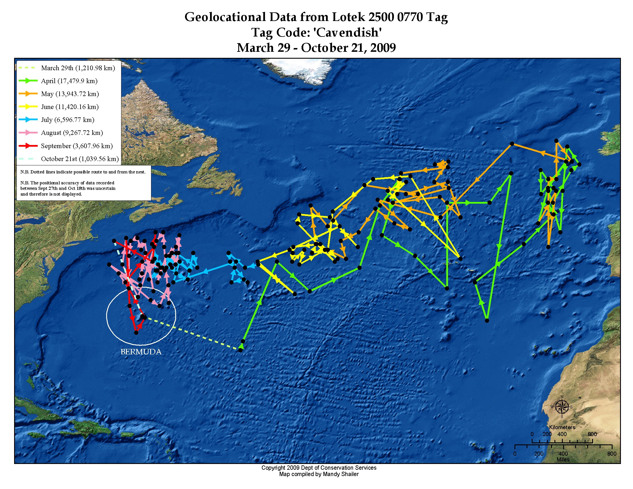
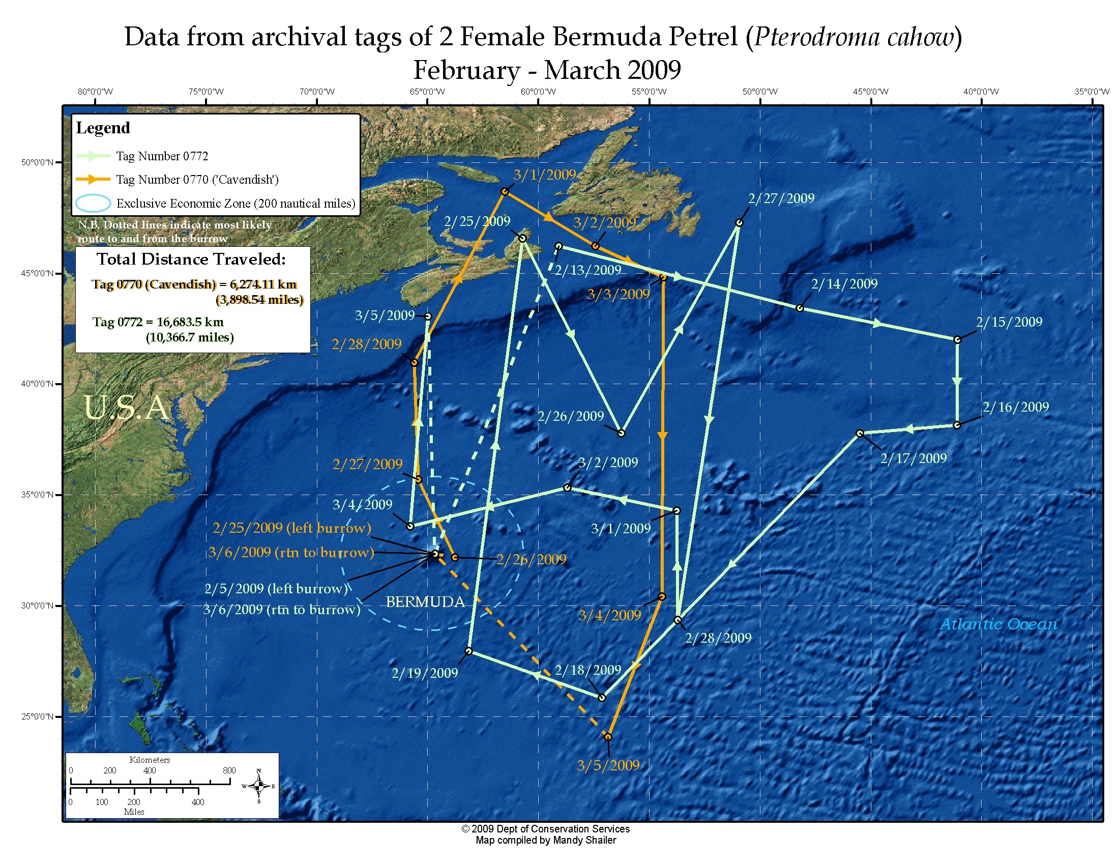
Geolocator Maps from 2009 study
Letizia Campioni | MARE-ISPA IU “Our project will enhance the ongoing Cahow Recovery Program by shedding light on their pelagic foraging behaviors and potential risks that they may encounter on the high-seas.”
Mónica C Silva | cE3c-FCUL “We are running a project with North East Atlantic Gadfly Petrels and we suspect that their foraging grounds may overlap exposing them to the same risks.”
The local Team has observed that over the past 2 seasons and continuing into this one, that foraging trips appear to be becoming shorter and more frequent. Cahows feed on cold water fish and squid traditionally found hundreds or even thousands of miles away in the North Atlantic basin, north of the Gulf Stream, but these shorter excursions raise the question as to where they may now be foraging, which this study will help answer.
Jeremy Madeiros | “Limited studies with geolocator tags in 2009-2010 made me realize that the Cahow can cover most of the North Atlantic Ocean in its yearly travels, but these had a large margin of error and were just a beginning for this study. I am excited about our collaboration with Letizia and Monica and the potential to focus in greater detail on important feeding areas for the Cahow and other aspects of its oceanic travels with these much more accurate GPS tags."
The longer-term geolocator tags register the time of day that the sun appears to rise and set and once this data is retrieved calculations are made to determine where in the world the subject would have had to be (within a 100 mile radius) for the sun to rise or set at the recorded time, giving their approximate location at sunrise and sunset each day for months on end.
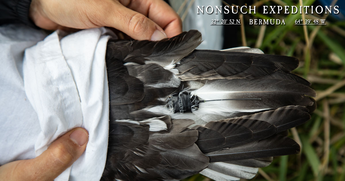
GPS tag taped to tail feathers on Cahow
This season, the shorter-duration, but much more accurate GPS tags will be set to record the time required to contact the numerous GPS satellites at set intervals, which once retrieved can then be extrapolated to identify the GPS locations. In this way the tags do not need to process or calculate the actual GPS location in realtime which would require much larger batteries and processing power…
This allows the tags to weigh only 3 grams and when set to record at hourly intervals, the battery will last up to 2 weeks.
Jean-Pierre Rouja | The Nonsuch Expeditions “Not only will this data be useful to the Cahow Recovery effort, but we will integrate it into the STEAM Curriculum that we are developing with Cornell, giving students interactive real-world data to work with.”

The Portuguese Team is supported by a grant from The Mohamed bin Zayed Species Conservation Fund.